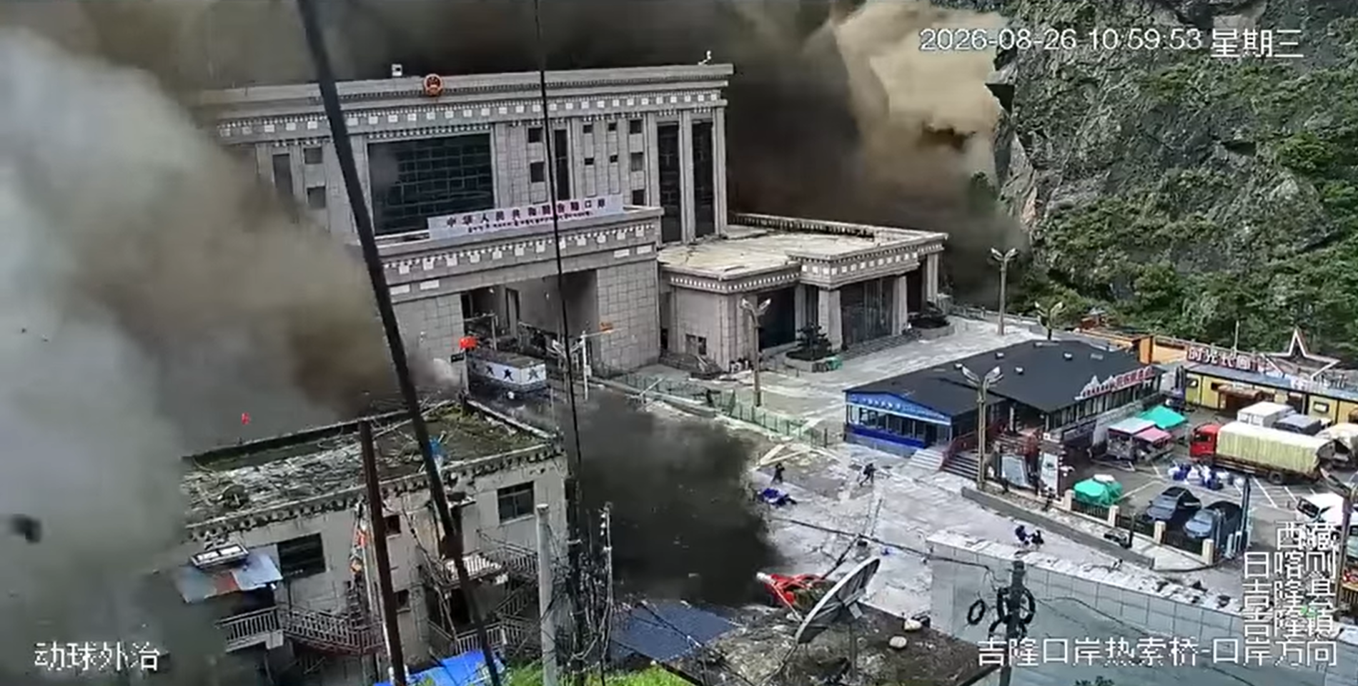
The catastrophic floods that struck the Nepal-Tibet border on August 26 were initially blamed on an earthquake. Scientists have since established that a large section of Himalayan glacier sheared away and collapsed, triggering the flash floods. The US Geological Survey initially logged the seismic signal as a magnitude 4.4 earthquake, before revising its assessment: the tremor, ultimately measured at magnitude 5.2, was generated by the landslide itself rather than a tectonic activity. Why the glacier failed remains under investigation, but scientists are examining warming temperatures, glacier instability, water accumulation, steep Himalayan terrain and the possibility of sudden mechanical failure.
A Glacier Did Not Simply “Melt and Fall”
A glacier collapse differs fundamentally from ordinary melting. A glacier behaves like a slow-moving river of ice, its stability governed by gravity, the strength of the ice, basal friction and the surrounding rock and frozen ground. On August 26, a large section sheared away and crashed down the mountain, generating an ice-and-rock avalanche that entered the Lhende river system and sent a powerful surge downstream.
Deeper Factor: A Warming Tibetan Plateau
Climate change cannot yet be called the immediate trigger, but it remains the crucial backdrop. The Tibetan Plateau is warming considerably faster than the global average – southeastern Tibet is estimated to be warming at around 0.42°C per decade, roughly double the global rate. This accelerates glacier mass loss, alters ice flow and destabilises permafrost, which acts as a natural cement holding slopes together. None of this proves a single collapse was climate-driven, but it widens the conditions under which one becomes possible.
Instability Turns Into Catastrophe
Water is often the decisive ingredient. Meltwater and heavy rainfall can penetrate a glacier’s cracks and reach its bed, lubricating the interface between ice and rock. Researchers studying the 2016 Aru glacier collapses in Tibet found this exact mechanism at work: water built up beneath the ice until frozen margins holding it in place suddenly failed.
Geography Made the Consequences Worse
Satellite imagery shows a section of glacier broke away at an altitude of roughly 5,200 metres and plunged about 1,200 metres to the valley floor, gathering rock and sediment as it fell. The resulting avalanche struck the Lhende river about 20 km northeast of the Rasuwagadhi border crossing, temporarily damming it. When that natural dam gave way, it released a debris-laden torrent that tore through the Bhote Koshi river system into Nepal, destroying homes, hydropower plants, roads and border infrastructure. Notably, the same Lhende Khola system has now flooded twice in fourteen months, and Chinese authorities have since warned that a new barrier lake has formed, raising the risk of a further outburst.
Was Climate Change Responsible?
That question cannot yet be answered with certainty. The immediate physical cause was the glacier’s failure and the resulting avalanche; whether warming directly triggered that particular section’s collapse will require detailed analysis of satellite imagery, ice movement, rainfall and glacier structure. What scientists can say with confidence is that a warming climate is making the Himalayan cryosphere increasingly unstable, with rising glacial-lake activity across the wider region. The tragedy on the Tibet–Nepal border is a geological event, but the conditions that produced it are increasingly shaped by a changing climate.
Has the Debris Dam on the Tibet Side Broken?
Not yet – and that is precisely what has authorities worried. The mass of ice, rock and sediment that blocked the river during the initial collapse has left a barrier lake forming on the Chinese side, near where Nepal’s Chhochen Khola meets the Purepu Tsangpo, which flows onward into China. China’s Ministry of Water Resources has cautioned that the lake carries a “high risk” of breaching, which could unleash renewed flooding on the already-devastated Gyirong Port crossing and endanger rescue teams working the area.
Officials estimate that some three million cubic metres of additional water – roughly 1,200 Olympic swimming pools’ worth – will flow into the dammed lake over the following days, with peak flow, and therefore peak breach risk, expected around September 1. Nepal’s disaster authority has separately issued its own notice warning residents, rescuers and passengers along the lower banks to stay clear of the riverside and other at-risk zones. Should the barrier fail, it would echo the very mechanism that caused Wednesday’s disaster in the first place: a natural dam holding back a mounting volume of water until the pressure becomes too great, then releasing it downstream all at once.
The Human Cost
The disaster has proven devastating. Nepali police have reported at least 469 deaths, with more than 1,300 people still missing, while Chinese state media has confirmed three deaths and hundreds missing in Tibet’s Gyirong county, including 260 foreign nationals. In Nepal’s hard-hit Nuwakot district, entire buildings were buried to their second storeys in mud, with survivors left caked in sediment and debris hanging from trees and power lines. At least 19 bridges and roughly 40 km of road have been destroyed, hampering rescue efforts in terrain that is difficult to access even in normal conditions. With almost no warning before the surge arrived, many residents had little chance to flee, and officials expect the toll to rise further as search teams reach cut-off communities.
Scale of the Rescue Effort
The rescue operation has grown into one of the largest in Nepal’s recent history. Nepal’s deployment has swelled to roughly 13,295 soldiers, police and armed police personnel combing the valley on foot and by air, while China has dispatched more than 681 firefighters, 13 rescue dogs, 113 vehicles and 47 drones to Gyirong county alone. On the Chinese side, authorities have already relocated 555 stranded tourists and evacuated 499 affected villagers, with South Korea separately assembling a rapid-response team after eight of its nationals working on a hydropower project went missing. Even with this scale of manpower, rescuers are struggling against washed-out roads, severed communications and the threat of further landslides, leaving many of the missing still out of contact rather than confirmed dead.
Could India, Bangladesh or Kathmandu Be Next?
India is already responding, not merely watching. Several rivers that drain the affected catchment – the Gandak, Bagmati, Kosi and Karnali (called the Ghaghara in India) – flow directly from Nepal’s mountains into Bihar and Uttar Pradesh, giving the disaster a built-in downstream pathway. Bihar’s authorities have opened all 36 gates of the Gandak Barrage at Valmikinagar as a precaution, with West Champaran, East Champaran, Gopalganj, Saran, Muzaffarpur and Vaishali districts placed on alert, alongside Maharajganj and Kushinagar in Uttar Pradesh. Officials have projected an inflow of roughly 250,000 cusecs through the barrage. India’s Ministry of Home Affairs is tracking river levels along the border, and Prime Minister Narendra Modi has pledged assistance to Nepal, including relief supplies and support for search-and-rescue efforts.
Bangladesh does not appear in current official warnings tied to this specific event. The Nepali rivers most implicated – the Trishuli, Bhote Koshi and Gandak – largely discharge their surge within Nepal and northern India before joining the wider Ganges system, where the volume dissipates considerably by the time it would reach Bangladesh, hundreds of kilometres further downstream. Unlike the 2024 Nepal floods, which did reach parts of northern Bangladesh, no agency has yet flagged a comparable cross-border threat this time, though this may change if the barrier lake in Tibet breaches and adds further volume to the system.
Kathmandu itself sits outside the immediate flood path, but it has not escaped the disaster’s reach. The highway linking the capital to the affected border region has been severed, disrupting supply lines – including cooking-gas deliveries trucked in from India – and residents have been warned that prolonged closure could begin to strain daily life in the city if the route is not reopened soon.